Francis C. Carter Memorial Preserve, Charlestown, RI
On the Trail – Laura Orabone
WildforaRI, Winter 2017
 The Francis C. Carter Memorial Preserve, located in Charlestown, is Rhode Island’s second-largest nature preserve and is maintained by the state’s chapter of The Nature Conservancy. This 1,112- acre property was acquired in 2001 with help from The Champlin Foundations, the Doris Duke Charitable Foundation, and the Cove Point Foundation. The preserve is dedicated to Francis (“Frank”) C. Carter, who led the Champlin Foundations for many years.
The preserve encompasses an 11-mile corridor of open space between the glacial moraines of the Ninigret National Wildlife Refuge to the mixed eastern woodlands and grasslands of the state-owned Carolina Management Area. It is easily accessible from two locations: one at its eastern edge off Rte. 112 (also called Carolina Back Road) and another to the west off Old Mill Road. Originally offering more than five miles of well-marked trails, it has recently been expanded; however, since the new trails have yet to be included on official maps of the property, this guide will cover only the original trails.
The Old Mill Road entrance provides two parking areas – one near the trailhead for cars and another large enough to accommodate horse trailers and a manual pump for watering horses. Note that the gravel road leading to the parking area is not always well-graded. Equestrian trails are marked. Near this parking area, and throughout the preserve, you can find pink lady slipper orchids (Cypripedium acaule) in early spring. The ruins of a cellar hole are barely visible to the left, just past the trailhead.
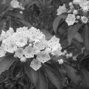
From this entrance, the Narragansett Trail takes visitors through stands of mountain laurel (Kalmia latifolia), sheep laurel (Kalmia angustifolia), black birch (Betula lenta), bracken fern (Pteridium aquilinum), mockernut hickory (Carya tomentosa), white oak (Quercus alba), white wood aster (Aster divaricatus), and eastern white pine (Pinus strobus). Other notable native plants include pipsissewa (Chimaphila umbellata), spotted wintergreen (Chimaphila maculata), and partridge berry (Mitchella repens).
The Narragansett Trail provides an easy walk to a 35-acre grassland surrounded by pitch pine and quaking aspen. This area, cleared in 2008 with the cooperation of The Nature Conservancy, The National Audubon Society, and the Rhode Island Department of Environmental Management, was recently expanded. It provides an important example of early successional habitat. Here you can see goldenrods, common milkweed (Asclepias syriaca), bayberry (Myrica pensylvanica), and a variety of native grasses and sedges. The adjacent uplands feature scarlet oak (Quercus coccinea), white oak (Quercus alba), pitch pine (Pinus rigida), and high-bush blueberry (Vaccinium corymbosum).
On warm spring evenings, when the peepers are in full swing, you can watch woodcocks performing their aerial courtship displays. The area also provides a nesting area for the state-threatened grasshopper sparrow, as well as the eastern towhee, scarlet tanager, and prairie warbler. American kestrels, brown thrashers, blue-winged warblers, and dozens of other birds may be observed here. A complete list is provided at the trailhead.
Off the Narragansett Trail is the short White Trail loop on the right. Before you reach the field, you can take a trail to the left leading through mostly pitch and white pine woods, with the occasional tulip poplar (Liriodendron tulipifera), eastern hemlock (Tsugacanadensis), and American holly (Ilex opaca). You may note an old chimney foundation here. This trail leads out to an open, sunny corridor created by a utility easement. The easement is home to lowbush blueberry (Vaccinium angustifolium), huckleberry (Gaylussacia spp.), sweet fern (Comptonia peregrina), and bird’s-foot violet (Viola pedata). Vernal ponds provide habitat for a variety of frogs and salamanders.
From the eastern trailhead off Carolina Back Road, you can explore the Yellow Trail and, if time permits, several other trails branching off from it. The Yellow Trail leads past a vernal pond to the right, then west through woodlands to the western trailhead off Old Mill Road. In the fall, small stands of witch hazel (Hamamelis virginiana) come into delicate bloom. The first left is the Split-Rock Trail, which follows a small loop before rejoining the Yellow Trail. The first right is the Red Trail, which meanders to the northeast and then curves back to the west through mixed hardwoods and pine, eventually joining the Blue Trail, which loops twice off the Yellow Trail.
Along both the Red and Blue Trails, there are several water features: trick- ling brooks, swamp areas dotted with skunk cabbage (Symplocarpus foetidus), and a pond off to the northeast of a portion of the Blue Trail. The pond is barely visible through the trees, and there is a rough wooden bench at this point to rest and listen. Along the middle section of the Yellow Trail, note the mysterious cairns or “turtle rocks” that dot the gently rolling landscape. Their significance is unknown; some claim they were built by early colonial farmers clearing stones from fields, while others attribute them to the Narragansett people. Also of note are several impressive granite boulders left behind by retreating glaciers at the end of the last Ice Age. Many of these are thickly plastered with rock tripe and topped with lush layers of mosses and ferns.
The Francis C. Carter Memorial Preserve is ideal for both short hikes and longer excursions. Allow 45 minutes for each trail; however, the shorter loop trails are suitable for briefer jaunts, ideal for families with young children. Although the terrain is not generally rugged, a hiking stick can be a helpful thing to have for extra stability.

Observe the following guidelines:
- Stay on the walking trails, using marked trails wherever they exist.
- Respect the preserve’s open hours (one hour before sunrise to one hour after sun- set). Overnight camping is not allowed.
- Do not use bikes or motorized vehicles in the preserve.
- Do not disturb bird nesting areas.
- Do not remove any living materials or disturb any vegetation.
- Remove your own trash and, if possible, any garbage that you see left by others.
- During the deer bow-hunting season at the preserve (September 15 – January 31), wear a fluorescent orange hat or vest.
- Leash your dog at all times.
To reach the preserve:
From Route 1, take the Route 2 exit north. Take Route 112 until you reach Old Mill Road on your left. The gravel road to the western parking area is near the utility easement, to the right where the road turns sharply to the left.
From Route 138 West, take a left onto Richmond Townhouse Road (aka Route 112) at the Richmond Town Hall. Continue south for .2 miles, past the Charlestown Elementary School. The unpaved road leading to the eastern trailhead is to your right. Or drive on a short distance and take the first right onto Old Mill Road for the equestrian parking area and western trailhead.