On the Trail — by Clark Collins
WildfloraRI, Spring 2014
The DuVal Trail, located in the village of Perryville on the north side of the Old Post Road is a three-mile network of rustic trails looping through the 240-acre Susanna’s Woods nature preserve. The preserve includes 167 acres that are held by the South Kingstown Land Trust either in fee title or conservation easement, and 74 acres that are owned by the Rhode Island Department of Environmental Management.
The late Helena-Hope Gammell, a founding member of SKLT initiated this trail system in 1983 with her first land donation of four acres, and continued to add to the preserve by donating other parcels and conservation easements over her land as well as financial assistance the acquisition of abutting properties. The entire project is named Susanna’s Woods in memory of Miss Gammell’s niece, Susannah Klebovitz. Expansion of the reserve has continued to the present year (2013) with a major land donation of 29 acres bequeathed in the will of Virginia Jones, her neighbor and collaborator. The trail itself is named in memory of Susan B. Duval, whose bequest helped pay for the trail and development. Additional assistance has been received from the National Park Service Rivers & Trails Program.
The DuVal Trail system offers some of the Land Trust’s most inviting and unique hiking experiences. The main entrance is located adjacent to the historic graveyard and former site of the Western Meeting House of the South Kingstown Friends (Quaker) Meeting, dating from the late seventeenth to the late nineteenth centuries. George Fox, the founder of the Religious Society of Friends, is said to have spoken at the meetinghouse during his tour of the American colonies in 1672.
From the parking area in front of the cemetery, the marked trail progresses up into the hill country known as the Charlestown Recessional Moraine, a long band of hills and valleys stretching from Wakefield, RI, to Watch Hill and farther down the north shore of Long Island, NY, which accumulated as poorly sorted glacial debris some 12,000 years ago as the edge of the glacier paused in its recession.
Most of the rocks are igneous and metamorphic (granite, schist, gneiss) derived from the bedrock in the surrounding area and to the north. The relief between the hilltops and valley floors range from 20 to 50 feet and slopes are often quite abrupt—between 15 and 30 percent. The soils are droughty, extremely stony and acidic. Due to their poor soil quality and inaccessibility most of these hills generally served as woodlots for the plantations located in the adjoining more fertile coastal plain. Some of the old cart paths from this period are still visible. Some isolated hollows have tillable soils that supported small homesteads in the past, and you may see here and there remnants of stonewalls and foundations.
Almost all of this area is now reforested with white, scarlet and black oak, sassafras, white pine, pitch pine, American beech, hickory and other trees common in the mixed upland forest of southern New England. Areas along the east of the trail head were planted with white pine and hemlock during the 1970s as a tree farm and habitat improvement program sponsored by the USDA Soil Conservation Service (now the Natural Resources Conservation Service), but there has been no tree harvest in this area due to its challenging topography. Linden trees still stand along an abandoned road to the Jones Camp in the western part of the preserve.

Lichen
There is a dense understory of huckleberry and low- highbush blueberry, with thickets of mountain laurel, Sheep-laurel, inkberry, green briar and ferns. There is little sign of infestation by exotic, invasive vegetation due to its undisturbed condition and to the control of Russian olive that has taken place according to a forest management plan developed in 2003. On the many exposed boulders and stones and trees along the trail there is a diverse population of lichens, mushrooms and fungi.
Throughout the year the charms of the trail system are many. As the trail climbs and descends among the hills and hollows, the visitor sees the landscape from many angles, and the three loop trails off the main trail introduce a diversity of microclimates created by variations in sun exposure to the slopes, differences in soil fertility and water tables, and vegetation. An overlook on the main trail has a clear view to the south over the coastal plain, the Trustom Pond National Wildlife Refuge and, in the distance , Block Island.
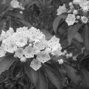
Mountain Laurel
In mid-June the trails are spectacularly decorated by blooms of mountain laurel. In late summer birds on their southward migration stop to rest and feed on the berry bushes. The new Jones Camp spur trail passes to the north through well-preserved old stone enclosures and leads to Bull Head Pond, a glacial kettle-hole pond.
Birds common to the area include wood thrush, hermit thrush, whip-poor-will, oven bird, wild turkey, towhee, vireo, yellow-rumped warbler, pine warbler, common yellowthroat, nuthatch, chickadee, and titmouse; also hairy, downy, and red–bellied woodpeckers; red, merlin, and sharp-shinned and Cooper’s hawks; ruffed grouse, junco, robin, veery, red tail hawk, great horned owl and barred owl, field sparrow, chipping sparrow, ruby crowned kinglet, brown creeper, and yellow-bellied sapsucker. (I gave up trying to figure which of these bird names should be capitalized. Some of them are a specific species, and some are general.)
We would rate the difficulty of the walk as moderate; the paths are marked with blazes and have location maps at the trail head and at the intersections of loop trails and the main trail. They are kept in a natural state at a cleared width of approximately four to six feet by rotary brush mowers and lopping shears. The trail is designed to avoid steep, erodible slopes and conform to the gentler contours, while seeking out interesting features such as large boulders, stone walls, remarkable vegetation and rare views. Sites that are habitat for rare or endangered plants or animals are avoided.
• Access to the trails by motor vehicle is limited only to the trail head on Post Road, and a pull-off area on Gravelly Hill Road. In few places the trails have climbs of 15 percent, and hikers should watch their footing for slope, rocks and roots. This trail is not handicapped accessible.
• Hunting is prohibited within 500 feet of the trails, but deer hunting in season may be allowed on other off-trail parts of the surrounding properties. Wearing high-visibility orange clothing is recommended on all wooded paths during deer hunting seasons.
• Hikers are advised that this area is likely to have ticks, and that tick repellents and close inspection for ticks after hiking is advised.
• We hope that you will visit this site, and enjoy it is much as we at the South Kingstown Land Trust do. Please contact Clarkson Collins at clark.collins@sklt.org to share any observations or experiences you may have on the trails.
Driving directions:
From Wakefield proceed Southwest on Main Street for 1.49 miles to Route 1. Stay on Route 1 South for about 2.9 miles then take the exit marked Post Road / Perryville. Proceed 0.31 miles to a stop sign at the intersection of Ministerial Road (Route 110). Go straight on Post Road for 1.28 miles, passing Moonstone Beach Road on your left, to a parking area on the right at the foot of the Quaker Burial Ground. The trail begins about 50 feet west of the parking area on the same side.
A trail map is available on the South Kingstown Land Trust website, sklt.org.

 Beyond the boxelder stand is a large pond on the right, residue from aborted development, but perhaps someday it will be a lovely aquatic system. A left turn at this point puts one on a green loop trail leading to the Palmer River estuary. This is where the upland woods change to a maritime shrubland transitional cover, then salt marsh. Like all ecotones, this one is rich in plant diversity, ideal for field botanists keying out species. Enter Doug McGrady, the Society’s plant wizard. Doug has compiled a comprehensive inventory of Haile Farm Preserve plants, and many interesting ones are in this area–ragged thoroughwort (Eupatorium pilosum), bushy bluestem (Andropogon glomeratus), yellow thistle (Cirsium horridulum), and white-fringed bog-orchid (Platanthera blephariglottis), the last two being state-threatened species.
 The Francis C. Carter Memorial Preserve, located in Charlestown, is Rhode Island’s second-largest nature preserve and is maintained by the state’s chapter of The Nature Conservancy. This 1,112- acre property was acquired in 2001 with help from The Champlin Foundations, the Doris Duke Charitable Foundation, and the Cove Point Foundation. The preserve is dedicated to Francis (“Frank”) C. Carter, who led the Champlin Foundations for many years.
