Mark posts with this category that are designated for the self guided walks page.

Weetamoo Woods, Tiverton RI

On the Trail — by Garry Plunkett
WildfloraRI, Spring 2015

Weetamoo Woods in Tiverton is the centerpiece of one of the few remaining large continuous canopy forest preserves along the coast of southeastern New England. Together with Pardon Gray Preserve and the Pocasset Ridge Conservation Area, over 1,500 acres of forest in Tiverton are protected. An unbroken stand of this size has important ecological value, particularly for wildlife species that need significant interior forest shelter to thrive.

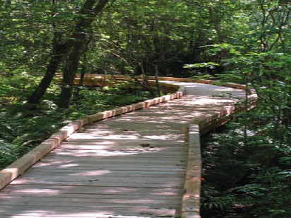
There are diverse habitats for visitors to see along the eight miles of trails that weave through Weetamoo Woods and the neighboring Pardon Gray Preserve. There is, however, a challenge for those who come looking for botanical excitement – the temptation to put away the field guide in favor of exploring archeology. Many footprints from the area’s past lie in the Woods of Weetamoo: cellar holes and stone walls from long-abandoned home sites, remains of a 19th century sawmill, and prominent scars from the last glacier whose retreat scoured out the nearby Sakonnet Passage.

The main trailhead of Weetamoo Woods is off East Road about a ¼-mile east of Tiverton Four Corners. The trail leading from the parking area is an old right-of-way originally surveyed in 1681, when Plymouth Colony was still recovering from the war. This original “Eight Rod Way” continues northward over three miles through the entire greater Pocassetlands forest preserve. Most of it is indistinguishable now, but it is quite evident for a twenty-minute walk beyond the trailhead.

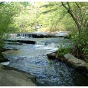
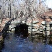
Ten minutes into that walk is a massive, slab-stone bridge spanning Borden Brook, and Eight Rod Way still has rude cobblestones that likely came from a nearby field. Pausing to reflect on how that bridge was built before the age of power machinery, one can imagine the rattle of oxcart wheels passing by.

Garry Plunkett - photo

Garry Plunkett – photo

Borden Brook is the main waterway that drains the 150-acre cedar swamp in the core of Weetamoo Woods. This stream also provided power for a sawmill that operated in the 19th century. The stonework complex of that mill is further up the trail, including the millpond dam, the millrace, and a marvelous dry stone bridge that arches across the race.

Old recorded names for trees are unreliable, but “cedar swamp” probably refers to what once was an Atlantic White Cedar swamp. These were common in colonial times along the Atlantic seaboard, but are threatened today. Scattered Cedars (Chamaecyparis thyoides) can be seen along the trails, and a small stand survives in the interior. But the wetland is now more of a red maple –deciduous shrub swamp, possibly due to the sawmill cutting out the cedars. They do not stump sprout, so regeneration back to a cedar community would have been thwarted by a clear-cut.

Much of the upland surrounding Cedar Swamp is mixed oak–American holly forest, found in coastal Rhode Island where slightly warmer maritime temperatures result in American Holly (Ilex opaca) being part of the sub canopy. Black and scarlet Oaks, Red Maple, Yellow and Black Birches, and Beech are in this community, with Blueberry and Sweet Pepperbush in the understory.

The American Holly has the “distinction” of being New England’s only native broadleaf evergreen tree. Broadleaf evergreens are dominant in tropical forests, but those species gradually disappear from forests going northward, replaced by deciduous and conifer trees. The last species in forests this far north is our native holly, and its glossy, green leaves and red berries are a welcome addition to rather colorless winter woodlands.

Along a low, north-south ridgeline in the north end of Weetamoo Woods are drier, rockier soils, so the forest transitions to mixed oak/hickory forest. The hollies are fewer, and there are more Hickory (Carya spp.), Sassafras (Sassafras albidum), Black Cherry (Prunus serotina), and Hop-hornbeam (Ostrya virginiana) trees, with an understory dominated by Huckleberry (Gaylussacia baccata).

The total area of Weetamoo Woods is about 650 acres, almost all of it mid-successional forest. The oldest trees are around 100–125 years old–those individuals that were young and pliable enough to survive the 1938 Hurricane. There are, however, a few older tupelos (Nyssa sylvatica), perhaps in the 200–300 year range. Their famously twisted grain makes them less susceptible to hurricane wind throw, and they are practically unsplittable, so they were shunned as firewood.

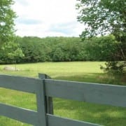
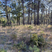
 There is one non-forested habitat to be seen, the result of a long-term restoration project. It was completed three years ago and adds significant wildlife diversity to Weetamoo Woods. Twelve acres of old plow-land next to Eight Rod Way had been abandoned a few years before it was acquired and added to the preserve. With help from a U.S. Fish and Wildlife Service grant, the interior hedgerows were removed and the entire area restored to create a single, unbroken meadow. The sweeping view of this grassland is beautiful, and it is being managed to sustain quality habitat for severely threatened ground-nesting birds and edge species. A partnership with a local farmer for late-season haying, along with edge mowing over the winter, has resulted in noticeable increases in bird species.

In the spring Weetamoo hikers may be lucky enough to enjoy the raucous mating chorus of wood frogs, since the topography is perfect for vernal pools. Isolated bowls of poor drainage are scattered throughout the forest, so on a quiet, sunny day following the “annual migration” of amphibians, the ducky chattering of wood frogs can be a cheery accompaniment to a springtime outing.

The flora of Weetamoo Woods is typical to the forest types described above; oak-dominated ones found in rocky, acidic soils that range from poorly drained, sphagnum dominated wetlands to barren granite outcrops. Common shrubs of the understory are Spicebush (Lindera benzoin), Highbush Blueberry (Vaccinium corymbosum), Huckleberry, Arrowwood (Viburnum dentatum), Nannyberry (Viburnum lentago), Sweet Pepperbush (Clethra alnifolia), Elderberry (Sambucus canadensis), Wild Sarsaparilla (Aralia nudicaulis), and Winterberry (Ilex verticillata). There are also some pure patches of Mountain Laurel (Kalmia latifolia) that can be spectacular around the third week of June.

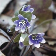
The spring wildflower array along the trails includes Sessile-leaved Bellwort (Uvularia sessilifolia), Wild Columbine (Aquilegia canadensis), Canada Mayflower (Maianthemum canadense), Dwarf Ginseng (Panex trifolius), Wild Geranium (Geranium maculatum), Jack-in-the-pulpit (Arisaema triphyllum), Wood Anemone (Anemone quinquefolia), Pink Lady Slipper (Cypripedium acaule), and Squaw-root (Conopholis americana). The Squaw-root is an interesting member of the broom-rape family of parasites. It grows on oak tree roots and looks like a small, pointed ear of corn coming out of the ground. It is state-listed (concern) and perhaps the best population is in Weetamoo Woods, where it can be seen in May near the sawmill.

As in all our woodlands, the floral display diminishes in summer. A few to be seen are Whorled Loosestrife (Lysimachia quadrifolia), Cardinal Flower (Lobelia cardinalis), Indian Pipe (Monatropa uniflora), and Indian Cucumber-root (Medeola virginiana).

A summer visit to Weetamoo Woods is well worth the drive to East Bay. There is history, diverse habitats, and the ultimate reward–cooling off at Tiverton Four Corners with a double dip of Gray’s Ice Cream.


Two Short Hikes in Scituate, RI

On the Trail — by Paul Dolan
WildfloraRI,  Winter 2015

Trott/Perry Trail

Trott PerryTrott/Perry trail is located along the eastern banks of the Pawtuxet River in the northern end of Hope Village and is accessed primarily from South and North Doctor’s Lane, off North Road (Rt. 116). It is less than a mile in distance but opens to other parcels in the area. Two local land preservations, Drs. Raymond H. Trott and Thomas Perry acquired this parcel in the early 1990’s. Walking trails have been featured since 2005 when the Forest Stewardship Plan began to manage the site.  Logging operations on this track, previously used a tree farm, were completed in the fall of 2014. Strolling through the area, you can see the stumps and how the land was managed, and also witness the new and diverse array of vegetation that is now claiming the area. This site will be an excellent site for citizen’s science, as it contains most of the standard trees that one would find in a typical northern Rhode Island woodlot. As the trail wanders along, the changes in habitat influenced by power lines cutting through the area become apparent, especially at the forest edge along the Pawtuxet River and the old Christmas tree plantation where the trees have grown to pole size.

In other areas, one can see the remnants of the first successional fields. Hikers can expect to see red, white, black, and scarlet oak; white pine, red cedar, sassafras, Norway and white spruce, American chest- nut, sweet pepper bush, huckleberries, and of course the ever-present bull briers. This is a nice, easy hike nestled in a busy community.

Directions: From the intersection of Route 12/116, continue south on Route 116 (passing the Providence Water Treatment Plant on the left) for approximately 1.7 miles and turn right onto Doctor’s Lane. Go about 1/10 mile to the parking lot on right.


 Westconnaug Meadows

Westconnaug MeadowsThe Scituate Land Trust has owned Westconnaug Meadows, located in the village of Clayville for over two decades. In that time, it has been developed as an educational outreach and hiking area. The trail system follows the paths of old deer runs. The parcel contains red maple swamps, American chestnut, old field species, glacial boulders, and woodland resulting from the successive impacts of agriculture, overcutting, fire and land abandonment. Spring peepers, the proliferation of deer, and the novelty of stands of chestnut oaks provide this woodlot with year-round interest. Other species found here include tupelo, white, red, and black oak; gray birch, sassafras, white pine, arrow-wood, sweet pepper bush, witchhazel, huckleberries, and high- bush blueberries.

The area has a real “off the beaten path” feel to it, especially once you reach the trail’s midpoint. This 1 to 1.25 mile hike skirts hundreds of acres of Providence Water Water Supply Trust land. Starting at the trailhead at the north end of parking lot, progress through a wetland with a wooden bridge system. Continue through old field white pine and gray birch, signs that this area was cleared at one point. Beyond a stone wall, the tree species change to mixed upland oaks as the site gets drier. Go about 1,100 feet to a fork in the path. Follow the left fork; as you walk, note small piles of stones and scattered American chestnut sprouts. After about 1,800 feet, you will come to a small scenic overlook that looks down on the head- waters of a small stream running to the Scituate Reservoir. Follow this small ridge for a while; here, chestnut oaks start becoming prevalent. At this point you will be able to see red oak and hickory trees in the ravine to your left, and wetlands with scattered vernal pools. The area has occasional erratic boulders left behind by the glaciers. Follow the marked route back to the first fork in  the path. Turn left and follow the path back to the parking lot.


Directions: Trailhead 41°46’0.18″N, 71°40’18.46″W
Take RI 102 to Clayville. In Clayville, turn onto Field Hill Road. Follow Field Hill Road to George Washington Highway. Clayville Elementary School is on the right. Turn right onto George Washington Highway and continue for a half mile. The parking lot is on the left in front of the baseball field.

.

Wickford Harbor Islands, Wickford, RI

On the Trail — by Sindy Hempstead
WildfloraRI, Winter 2013

Islands are little worlds of their own. Two of these little worlds, Rabbit and Cornelius Islands, eight and nineteen acres respectively grace the north-
west arm of Wickford Harbor in North Kingstown. Both are uninhabited by humans, though not by deer.
In the 1630s the wife of the
Narragansett Chief Canonicus, known as Queen Sachem, gave Rabbit Island,
then known as Queen’s Island, to Roger Williams for
his goats, because they were
making short work of her
gardens on the mainland.
Later, in 1651, Roger Williams
sold the island along with his trading post to William Smith. Rabbit Island has been part of the Smith’s Castle property ever since, and relatively undisturbed.

The south point of Rabbit Island is salt marsh, a watery meadow made up of Saltwater Cordgrass, (Spartina alterniflora), and the fleshy leaves of Glasswort (Salicornia europaea), which are bright red in autumn. Along the southwest shore the Spartina border narrows, and the land, rising steeply behind it, bears a dense band of Marsh Elder (Iva frutescens). Farther along there are patches of Spike Grass (Distichlis spicata) but no wide expanses of the Salt-hay Grass (Spartina patens) typical of many salt marshes. The edge of the island to the north and east is a beach that partially disappears at high tide. Here the Spartina alterniflora gives way to beach species such as robust clumps of Sea Lavender, (Limonium carolinianum), white daisy-like Marsh Asters (Aster tenuifolius), Seaside Goldenrod (Solidago sempervi- rens), Glasswort, and Sea-blite (Suaeda linearis).

The island itself consists of a central plateau, six to ten feet above sea level, surrounded by the gently sloping tidal flat that supports the salt marsh on its sheltered sections and beach where it is more exposed to wind and waves. In the center of the plateau is a cathedral-like forest, comprised of majestic Red, and a few White, Oaks (Quercus rubra and Q. alba) with a scattering of Gray Birch (Betula populifolia), Sassafras (Sassafras albidum), and Wild Black Cherry (Prunus serotina). A ring of large Red Cedars (Juniperus virginiana) surrounds the forest. The sparse understory includes Bayberry (Myrica pensylvanica), Sweet Fern (Comptonia peregrina), Poison Ivy, Bullbrier (Smilax sp.), and an occasional Spotted Wintergreen (Chimaphila maculata), but no delicate woodland wildflowers. The local deer swim over and partake of any luscious leaves that dare to appear above ground. The deer goodies apparently include tree seedlings, which doesn’t bode well for the future of the forest.

East of Rabbit Island, past Wickford Point and across the narrow channel that separates the island from the mainland lies Cornelius Island. Its topography is similar to that of Rabbit Island – a central plateau surrounded by salt marsh and beach – but its history is very different. Originally Cornelius Island was part of Wickford Point, then known as Calf’s Point. A 1660 survey shows the intact Calf’s Point; in the next survey, 1802, a channel separates Cornelius Island from the peninsula. How, why, and by whom the channel was dug remains unknown. Both islands were grazed and presumably logged by early settlers; however, Cornelius Island has been intensively used since then.

Old Stone House, showing signs of vandalism and forces of nature


In 1861 Earl Gardiner bought Cornelius Island and built a house on it that came to be known as the Old Stone House, the remains of which are clearly visible across the water from the west. In 1865 a company from Fall River bought the island in order to set up a smelly fish processing business producing fish oil and fertilizer, using the house as a cookhouse. Eight years later the local citizens voted to expel that unpleasantness from the town. Benjamin and Delia Northup then rented the Old Stone House, in which they raised a large family. Fishnet tarring and heavy duty gardening followed. Eventually in 1897 Capt. Rollin Mason bought the island and passed it on to his heirs who, in conjunction with the town of North Kingstown, still own it. The stone house, extant in 1935, became the headquarters of the Wickford Yacht Club. After the 1938 hurricane, however, the Yacht Club moved to the mainland. John Huszer, a well known local artist, lived in the house in the early 1960s until, in 1963, Wickford Harbor was dredged and the soils dumped on the eastern portion of the island, turning it into a barren hill of gray bottom muck. Although the stone house wasn’t buried, the island became uninhabitable. For the fifty years since then it has been relinquished to vandals and the forces of nature. As the vandals were more interested in destroying the Old Stone House than in the plant cover, the present vegetation of the eastern part of the island can be considered the result of forty-nine years of natural succession on harbor bottom soil.

On the north and west the vegetation is similar to that on Rabbit Island with a small forest of large trees, a band of Spartina alterniflora on the northwest shore, and beach species on the north and northeast.

A cursory plant inventory turned up 57 species on Cornelius Island as against 27 on Rabbit Island. The additional species on Cornelius are, unsurprisingly, mainly on the area of the dredge fill, which is treeless except for a few sturdy junipers within it and around the edges.

The most noticeable shrubs are rugosa rose, Smooth Sumac (Rhus glabra) and bayberry. The grasses, Little Bluestem and Switchgrass, are common as are many roadside species, including Cypress-spurge (Euphorbia ), Horseweed (Conyza Canadensis), Pokeweed (Phytolacca americana), Milkweed (Asclepias syriaca), Mullein (Verbascum thapsus), Rough Goldenrod (Solidago rugosa), Round-headed Bush-clover (Lespedeza capitatum), and Orach (Atriplex patula). There are invasives as well — Oriental Bittersweet, Autumn Olive, Japanese Honeysuckle, and Phragmites — although they aren’t as dominant as one might expect. One surprising find was three substantial Box-elder (Acer negundo) trees along the north shore, Box-elder being a common, almost weedy tree in the Midwest, but seldom seen in Rhode Island.

Exploration of Wickford Harbor with a walk on Cornelius Island and a look at the Old Stone House is a pleasant way to spend a summer afternoon. However, it might be best to forego a hike on Rabbit Island, because, after checking out the vegetation there, I noticed a “No Trespassing” sign.

Access: Wickford Harbor is easily accessible from the Wilson’s Park launching site, at the end of Intrepid Drive off Post Road, and canoes and kayaks are for rent from the Kayak Center at the south end of Brown Street in Wickford. The paddle from the boat rental dock to Cornelius Island is a pleasant mile’s paddle, the distance from the Wilson’s Park launching site to Rabbit Island is about 500 feet, and the distance between the islands is roughly a third of a mile.

References:

Clauson, J. Earl. 1935. “The Mystery of Cornelius Island.” The Village Fair News.
Cranston, Timothy. “The Islands of Wickford Harbor.” Personal communication.

Cranston, Timothy. 2000. “Cornelius Island.” The View from Swamptown.
Fagnant, Mimi Huszer. Personal communication.

Peckham, Ardelia Wyllie. 1974. “The Small Island with a Big Past.” The Standard-Times, North Kingstown, R.I. July 18, 1974.

Sherman, Nancy Whyte. Personal communication.
The North Kingstown Standard Times. Archives, 1962-3.


Maxwell Mays Wildlife Refuge

Maxwell Mays Wildlife Refuge, Coventry, RI

On the Trail – by Scott Rurhen
WildfloraRI, Spring/Summer 2013

Located in the beautiful rolling landscape of western Coventry, the Maxwell Mays Wildlife Refuge is the newest public refuge owned by the Audubon Society of Rhode Island. Attractive and rewarding in any season, the 295-acre Mays Refuge is a popular spring and early summer destination. Open from dawn to dusk, the Mays Refuge is marked by a large refuge sign along Victory Highway, Route 102, just north of Route 95. The approximately three miles of trails are clear, comfortable and well blazed. The shorter loop can be completed in 45 minutes to an hour; the full trail system takes two to three hours depending on speed and how often you stop.

This special place is named in honor of the long-time resident and refuge donor, the late artist Maxwell Mays. Mr. Mays donated the property to Audubon to preserve what he cherished for over sixty years. Looking from the parking lot you can see Maxwell Mays’s former home, owned at one time by Caleb Carr, the last colonial governor of Rhode Island.*

All trails at Mays start and end at the trailhead across from the parking lot. A kiosk displays facts about seasonal natural history. As you enter the refuge, trail maps and brochures are available in a box on the fence beneath a canopy of large White Pines (Pinus strobus). White Pines come and go along the hike but may be the most abundant tree species at Mays. As in many areas in Rhode Island, Red Pines (Pinus resinosa) were planted fifty to sixty years ago along this driveway. Stumps are evidence of these former residents.

The Carr Pond Trail (white blazes) runs along what used to be the pasture for Mr. Mays’ pony. Introduced and native grasses such as Little Bluestem (Schizachyrium scoparium) grow with native and introduced forbs. Some of the late spring to summer wildfl owers are Fragrant Bedstraw (Galium spp.), large clones of spreading Dogbane (Apocynum androsaemifolium), the great butterfl y plant, Common Milkweed (Asclepias syriaca), small White and Heath Asters (Aster vimineus and A. pilosus), Blue-eyed Grass (Sisyrinchium montanum) and a host of beautiful naturalized wildfl owers including Deptford Pinks (Dianthus armeria), Birds-foot Trefoil (Lotus corniculatus), Crown Vetch (Coronilla varia) and Butter-and-eggs (Linaria vulgaris).

Entering the next field, a hayfield, you are steered along the northern edge. Soon you will make your first hiking decision: to head into the forest or to continue south along the field edge, across the private driveway and into another section of forest? This is a complete loop trail so you will see the entire Carr Pond trail with either choice. Wild Geraniums (Geranium maculatum) line the sheltered edges of the forest.

If you choose to stay in the sun, you will see that in the drier forest edges, Bayberry (Myrica pensylvanica), Sweet Fern (Comptonia peregrina), Deer-tongue Grass (Dichanthelium clandestinum), Common Juniper (Juniperus communis), Tick Trefoils (Desmodium sp.) and Bush Clovers (Lespedeza sp.) thrive.

Maxwell Mays Wildlife Refuge

A peaceful field in the Maxwell Mays Wildlife Refuge.

Pink Lady-slipper Orchids (Cypripedium acaule), or Moccasin Flowers, are surprisingly common in the sun-dappled pine duff of the woodlands at Mays. Look also for the delicate green and white rosettes of Downy Rattlesnake Plantain (Goodyera pubescens) on the forest floor, nourished by decaying leaves of hardwood trees. Though not as abundant as other woodland perennials, when you find one of these orchids you typically find several.

The discrete Cow-wheat (Melampyrum lineare) and the showy white Canada Mayfl ower (Maianthemum canadense) and Starflower (Trientalis borealis) are common in May and June. Year-round color is provided by the ubiquitous Spotted Wintergreen (Chimaphila maculata), best known for its evergreen leaves with a white center streak. Look too for its completely green relative, Pipsissewa (Chimaphila umbellata), with neatly whorled leaves. Both of these woodland plants produce a few white to pinkish flowers in summer. The pleasant tasting Wintergreen (Gaultheria procumbens), also known as Teaberry, is identifiable by its glossy dark-green leaves and red fruit. Look for it creeping along sunny woodland trails.

Later in the summer, expect to find Indian Pipe (Monotropa unifl ora), that fascinating fungus-like plant that lacks chlorophyll. As summer wanes, White Wood Aster (Aster divaricatus) picks up the pace.

Carr Pond is your destination and a chimney from a long-lost house is the decision point and beginning of the Hammitt Hill Trail (yellow blazes) on the western shore of the pond. You can either do the rest of the Carr Pond Trail or head to Hammitt Hill, the 22nd highest peak in Rhode Island at 609 feet. You can imagine Native American and later European colonist, soldiers and farmers meeting at this summit or using it as an overlook of the formerly cleared landscape.

On the Hammitt Hill Trail notice the boulder fields, glacial erratics and an oak forest thick with Huckleberry (Gaylusacia spp.). Huckleberry is a sign of poor soil fertility and prior disturbance. History is sparse for this land but the rocky land was likely cleared for wood and charcoal and grazed by sheep and other livestock. In higher, drier forest patches along the way you will see other hardwoods including American Beech (Fagus grandifolia), as well as Pignut (Carya glabra) and Mockernut Hickories (C. tomentosa). Witch-hazel (Hamamelis virginianus), some very large, arch over the trails in places and grow up and down slope.

As you descend into cooler, moister portions of the trail look for new species. Though its flowers may be fading in early summer, Dwarf Ginseng (Panax trifolium) pops up along moister sections of trail. Pink to white flowers of Pinkster Azalea (Rhododendron nudifl orum) decorate random sunlit spots along the way in the sunny month of May. Wet, cool spots and stream sides harbor Sphagnum Moss (Sphagnum spp.), Skunk Cabbage (Symplocarpus foetidus), Jack-in-the-pulpit (Arisaema triphyllum and Spicebush (Lindera benzoin).

Beneath the canopy are shrubs and groundcovers such as wild Sarsaparilla (Aralia nudicaulis) with its clusters of greenish white flowers, patches of Mountain Laurel (Kalmia latifolia), scattered Sheep Laurel (Kalmia angustifolia) and High-bush Blueberry (Vaccinium corymbosum).

Ferns are also a big part of the Mays understory. Boulders on the Hammitt Hill Trail are often graced with a green mantle of Common Polypody (Polypodium virginianum), or Rock-cap. Rock outcrops may harbor Spleenworts (Asplenium sp.), mosses and countless lichens. Large swaths of Hay-scented Fern (Dennstaedtia punctilobula) carpet the forest floor beneath Red Maples and oaks. Look also for Cinnamon Fern (Osmunda cinnamomea), Christmas Fern (Polystichum acrostichoides), Royal Fern (Osmunda regalis), Interrupted Fern (Osmunda claytoniana) and New York Fern (Thelypteris noveboracensis), as well as several species of clubmoss, such as Shining Clubmoss (Lycopodium lucidulum), Ground Pine (L. obscurum) and Running Cedar or Creeping Jenny (L. digitatum). Sensitive Fern (Onoclea sensibilis) is predictably found in the sunny edges of meadows, trails and roadside at Mays, often joined by resilient Bracken Fern (Pteridium aquilinum).

Hammitt Hill Trail reconnects with the Carr Pond Trail, and you can follow this home. As you leave the forest and enter the meadows you are back where you started, with a short walk back to your car.

Scott Ruhren, Ph.D., Senior Director of Conservation with the Audubon Society of Rhode Island.


*Editors Note October 2020: We received feedback from a descendent of the Carr family who noted that the property was not connected to Caleb Carr but rather settled by his great grandson, Benjamin Carr 1778.  Additionally, Caleb Carr was not the last colonial governor in Rhode Island.

limerock preserve lincoln, ri

Limerock Preserve, Lincoln, RI

On the Trail — by Kathy Barton
WildfloraRI, Spring 2012

Each spring the Hepatica (Liverwort) lures me out to the Limerock Preserve of the Nature Conservancy in Lincoln, R.I. Wandering in the early spring woodland, poking through leaf litter, I begin to feel the changing rhythm of the seasons as winter gives way to spring and a new chapter of botanical exploration opens.

With a name like Limerock it shouldn’t be hard to figure out the area’s chief claim to fame. Surprisingly, though, the limestone for which the area is famous is really dolomitic marble. Regardless, because of this deposit, Limerock has given us a rich cultural and botanical heritage.

Limerock has been the home of quarrying operations since the 1660s when Thomas Harris and Gregory Dexter began a mining operation along what is now Route 146 in Lincoln. You can see one of the old quarries from the highway. The Conklin Limestone Company stopped working their last quarry in 2004 and allowed it to flood, thus ending 330 years of operation.

Unlike other New England colonies Rhode Island was blessed with an abundance of this easily quarried limestone for plaster and mortar, and this allowed for the development of stoneenders, a house design unique to Rhode Island. A stone-ender has a massive stone chimney made up of mortar and fieldstone. Usually, this chimney takes up all of one end wall. Locally, the Valentine Whitman House and the Eleazer Arnold House on Great Road, Lincoln. are surviving examples of this style. Around 1900, electric trolley car service was extended from Providence to Woonsocket and Burrillville. This trolley rocketed north to Woonsocket at 35 miles an hour.

The old rail bed forms the main trail of the preserve. Remains of the trolley line can be seen in the drainage ditches along the path. Two streams pass under the road bed through culverts that are still functioning. The line was abandoned in the early 1930s. The trolley bed/trail ends at Wake Robin plaza and condominiums. You can see the condos from the path. For those of you who in the past entered from this end of the preserve and remember having a rest break at Wendy’s, Wendy’s closed and was torn down in 2011.

In 1986 the Limerock Preserve became one of the fi rst properties in Rhode Island to be purchased and protected by the Nature Conservancy. At that time it was home to 30 rare species of plants, the largest population of any site in the state. The preserve was created thanks to the generosity of landowners Dorothy and Raymond Houghton, the Plante Family and the Wilbur Family. The Conklin Limestone Company donated the mineral rights. Additional support was provided by the Champlin Foundation and individual donors.

Unfortunately, a number of the rare plants have been lost. Round-leaved Yellow Violet (Viola rotundifolia) hasn’t been seen for about ten years. The Lilyleaved Twayblade (Liparis liliifolia) was lost when part of the ledge on which it was growing gave way in the 1990s. And Showy Orchis (Galearis spectabilis) is another that seems to have disappeared from the area. At one time Large Purple-fringed Orchid (Platanthera grandifl ora) grew, but I haven’t seen it in years. The trail system is very simple. It consists of the trolley line running straight from Wilbur Road almost to the Wake Robin plaza on Rte. 116 with a loop trail around the Manton Reservoir.

There’s a map posted at the trail head. You enter the Preserve from Wilbur Road and follow the trolley line a short distance. The trail turns left and goes up the embankment. Watch for this, because if you continue straight, you will find yourself wishing you had boots. The drainage system has broken down in this section of the road bed, and it fl oods out, especially in spring. On the bright side, this fl ooded out area functions as a vernal pool for the local amphibian population.

As you walk along the top of the embankment, notice the Common Shinleaf (Pyrola elliptica). You can also fi nd Beaked Hazelnut (Corylus americana) along the way. Looking down at the rail bed, the Christmas fern (Polystichum acrostichoides) and Wood Ferns (Dryopteris spp.) rejoice in the rich habitat and are rampant.

The trail eventually drops down and rejoins the trolley bed. Walking along, you can see Skunk Cabbage (Symplocarpus foetida), Wind Anemones (Anemone quinquefolia) Marsh Marigolds (Caltha palustris), Hop Hornbeams (Ostrya virginiana), Spicebush (Lindera benzoin), Black Birches (Betula lenta) and in spring hundreds of blue violets in bloom. Watch for the start of the loop trail on your right. A stream crosses it just where it joins the trolley line. Green and white markers are posted on the trees. If you look around on the left of the main trail, you may be able to fi nd Nodding Trillum (Trillium cernuum) hiding in the underbrush. This trail circles the reservoir, crossing a newly rebuilt dam. Watch for Hepatica along this trail. Hepatica grows where it pleases at Limerock and is apt to appear anywhere along the trails. Note: Taking the loop trail at this point allows you to walk down a very steep hill rather than up it, although I personally prefer walking it from the other direction.

Among other plants that may be seen on the refuge are Maidenhair Fern (Adiantum pedatum), Rattlesnake Fern Botrychium virginianum), White Baneberry (Actaea pachypoda), Perfoliate Bellwort (Uvularia perfoliata), Dwarf Ginseng (Panax trifolius), and Allegheny Crowfoot (Ranunculus allegheniensis).

When the loop trail rejoins the trolley line, take a left. Almost immediately the trail passes between rock outcroppings and ledges. The largest and last set of ledge is home to Wild Columbines (Aquilegia canadensis), Early Saxifrage (Saxifraga virginiensis), and Ebony Spleenwort (Asplenium platyneuron). From here, the rail bed crosses a ravine and is raised 20 to 30 feet above the surrounding land. There’s a nice view of both the Manton Reservoir and a brook that passes under the trail. Hepatica can be found along this trail. From here, it’s a straight run past the start of the loop trail and back to your car.

For me, Limerock Preserve is the quintessential northern Rhode Island spring woodland and viewing the Hepatica a rite of spring.

  Photos by Kathy Barton, taken at Limerock Preserve.

royal fern ri

Fort Barton Woods, Tiverton, RI

On the Trail — by Garry Plunkett
WildfloraRI, Winter 2012

Tiverton’s Fort Barton Woods is a gem of a natural area in East Bay that is well worth crossing a couple of bridges to visit. Its varied terrain, mature maritime hardwood forest and “babbling brook” are reason enough to come, but visitors will also be interested in the Revolutionary War history of the site. That story, as well as natural history information, is told in guides found in a trailhead box, or as a PDF you can download at Tiverton Beaches & Recreation.

The entrance and parking is at 343 Highland Road, across from Tiverton’s Town Hall, and there are interesting plants to see right from your car. Come in spring, maybe late April, and the face of the granite outcrop above the parking area will show off a population of dainty spring ephemerals, Early Saxifrage (Saxifraga virginiensis), a state-listed plant. There is also a small Northern Hackberry (Celtis occidentalis), a tree that’s common in the South but somewhat unusual in Rhode Island.

As you leave the street to walk up a paved approach to the Revolutionary War Redoubt, on the immediate right is a White Mulberry (Morus alba) that – at over two feet in diameter – has to be the state champion of this species. One suspects this huge specimen is an offspring of mulberries brought over by colonists in an abortive attempt to establish a silk industry. Continuing up the path takes you to a bluff where colonial troops established a major defensive position whose earthworks survive today.

The strategic need to fortify these Tiverton Highlands is evident when you climb the observation tower that overlooks the Sakonnet Passage, a narrow strait separating the mainland from Aquidneck Island, where thousands of British troops occupied Newport early in the Revolution. Eventually, the ill-fated Battle of Rhode Island was launched from Fort Barton, when thousands of colonial troops ferried across the Sakonnet in an attempt to drive the British off the island.

When the redoubt site was developed in the 1960s, it was cleared and planted in common ornamental shrubs, so visitors looking for native plants can proceed from the tower right to the trailhead at the rear of the redoubt area. Here a sign cautions visitors about uneven terrain and rustic bridges on the trails, so the usual advice for being careful and wearing sturdy shoes applies. In the vicinity of the sign are several patches of Herb Robert (Geranium robertianum), a plant with the curious distinction of being state-listed for protection in Rhode Island but also listed as a noxious invasive weed in Oregon.

Beyond the sign and halfway down the stairway on the right is an unusual tree, an American Basswood (Tilia americana), the New World’s version of a Linden Tree. It prefers rich, alkaline soils, which explains why it is scarce, maybe nonexistent, in the wild in Rhode Island and puzzling that this single tree is here on a rocky slope.

royal fern ri

Royal Fern
Osmaunda regalis

The trail proceeds along a narrow connector path to the 80-acre Fort Barton Woods, where the principal natural attraction is the lovely Sin and Flesh Brook winding toward Nanaquaket Pond. No, the brook’s name is not what you might think, but refers to a poor Quaker preacher who passed through Tiverton during the King Philip’s War and was ambushed by a band of Pocassets, and whose bloody body was discovered alongside the stream. Today this pristine stream is not bloody at all, but courses through towering Red Oaks, quiet fern glades, and within earshot of vernal pools quacking with wood frogs in the spring.

Go there in August when brilliant red Cardinal Flowers (Lobelia cardinalis) grace its banks, and the blue-green, checkered basal leaves of Downy Rattlesnake-plantain (Goodyera pubescens) hide in leaf litter beneath stems of this discreet little orchid. Or go in October when the otherwise demure Maple-leafed Viburnum (Viburnum acerifolium) proudly displays its rosy pink foliage in the understory.

Downy Rattlesnake-plantain

Downy Rattlesnake-plantain
Goodyera pubescens

Fort Barton Woods is also an excellent place to practice fern identification. The observant fernophile will find Netted Chain-fern (Woodwardia areolata), Crested Wood-fern (Dryopteris cristata), Silvery Spleenwort (Deparia acrostichoides), Royal Fern (Osmunda regalis), and Broad Beech-fern (Phegopteris hexagonoptera), along with the usual suite of common woodland ferns. The Crested Wood-ferns are in a Sphagnum-carpeted wetland, where there is also a state-listed tree that likes swamps, the Black Ash (Fraxinus nigra).

Alternatively, on some warm summer afternoon when you are in no mood for keying out ferns, Fort Barton Woods is a fine place to leave the iPhone at home, find a shady bend in the brook, hang your feet in the water and just listen to wood thrushes singing in the forest canopy.


fort barton tiverton, ti

ri fern dundery trail ri

Dundery Brook Trail, Little Compton, RI

On the Trail — by Dick Fisher & John Berg
WildfloraRI, Fall 2012

The Dundery Brook Trail in Little Compton, recently opened to the public, provides access to forested wetlands and freshwater swamps at Bumblebee Preserve, an extensive wild area that has been owned and managed by the Nature Conservancy since 2001. The trail wanders through a pristine coastal oak holly forest, crosses streams of several sizes that contribute to Dundery Brook, and arrives at Bumble Bee Pond.

dundery trail ri

The wheelchair-accessible boardwalk
allows for year-round access for
viewing wetland plants, whether
visitors travel on foot or with an
assistive device.

The unique feature of this trail is that the entire journey to Bumble Bee Pond and back, a round trip of 1.2 miles, is accomplished over an elevated boardwalk that is wheelchair accessible. Built of black locust timbers over simple steel piers, the structure provides for easy travel and yet protects the plants and animals that inhabit the preserve from disturbance.

The final portion is a grassy trail around Bumble Bee pond, extending into some old fi eld and meadow areas, which are “singing grounds” in early spring for American Woodcock. Whether visitors travel on foot or with an assistive device, the boardwalk allows for year-round access for viewing wetland plants, which is not usually possible on conventional trails.

At the outset, the trail enters into a woodland on mineral soils of Red Maple (Acer rubrum), Black Cherry (Prunus serotina) and Black Ash (Fraxinus nigra) through a grove of arching Speckled Alder (Alnus incana). The ground here in late June is covered with white blooming Dwarf Raspberry (Rubus pubescens). The trail soon enters a much wetter area, and within a few hundred feet the trail has a short diversion, allowing visitors to inspect a small, open bog containing cattails, grasses, and sedges. Surrounded by ferns, tree frogs and spring peepers command this space after spring rains.

Beyond the fi rst stream crossing, at a stone wall, the forest fl oor shows full development, and its canopy changes to include Black Gum (Nyssa sylvatica), of which there are some impressive clonal stands, American Beech (Fagus grandifolia), Black Ash (Fraxinus nigra), and a mixture of Black, Red and White Oak (Quercus velutina, coccinea, and alba). American Holly (opaca) is present throughout as the major sub-canopy species, as are Ironwood (Carpinus caroliniana), and American Hophornbeam (Ostrya virginiana). At one point near the fi nal third of the board walk there is a grove of eight or ten, 60-foot Sassafras (Sassafras albidum). Since there are few Sassafras in the understory, they are easy to miss, but once spotted these individuals are impressive.

In the open boggy areas, shrubs become prominent and include Smooth Arrowwood (Viburnum recognitum), Highbush Blueberry (Vaccinium corymbosum), Sweet Pepperbush (Clethra alnifolia), Winterberry (Ilex verticillata), and Swamp Azalea (Rhododendron viscosum), among many others. Herbaceous wetland plants are abundant as well in these shrub swamps, just below and to the sides of the trail. The blooming species vary with the season but multiple grasses, sedges, and horsetails occupy the ground layer year-round. Ferns are also abundant, lining the trail from end to end. At least eight fern species have been identified.

At the major brook crossing, which occurs in a sunny clearing that is lined with Buttonbush (Cephalanthus occidentalis), Black Elder (Sambucus canadensis), Spicebush (Lindera benzoin) and Winterberry (Ilex verticillata), deep stream channels are interspersed with mats of tall Reed Canary Grass (Phalaris arundinacia) and sedges.

The boardwalk trail comes to an end at an earthen dam that borders Bumble Bee Pond. Created for watering cattle in the 1940s, this retention pond has reverted to open water, marsh, and wet meadow habitats that are much used by waterfowl, amphibians, and spotted turtles. Cattail (Typha latifolia) dominates this area, but Common Reed (Phragmites australis) coexists, as does Sweet Flag (Acorus calamus). In perimeter areas, copses of willow abound, along with Shadblow (Amelanchier canadensis) and some relic Pears (Pyrus communis).

The plants mentioned are dominant species that define the habitat of the coastal oak—holly forest. Many more are of course present, which may be of special interest to individuals. An inventory completed a few years ago documented over 350 plant species at Bumble Bee Preserve and undoubtedly more exist. The special access that the elevated trail affords should yield more information about this wetland plant community over the next few years. Regardless of your mobility status come visit this unique environment and try the Dundery Brook Trail as a place for quiet reflection and a close look at wetland botany.


Access:
The trail head is located just west of the Little Compton Commons and the Wilbur & McMahon School behind the tennis courts. From Meeting House Lane turn north on to an unpaved lane adjacent to the baseball fields

Thomas G. Barnes @ USDA-NRCS PLANTS Database / Barnes, T.G., and S.W. Francis. 2004. Wildflowers and ferns of Kentucky. Univeristy Press of Kentucky

ben utter trail

Ben Utter Trail, Exeter, RI

On the Trail — By Doug McGrady
WildfloraRI, Spring 2011

The Ben Utter Trail in Arcadia is a great place to see the beauty of Rhode Island’s natural landscape. This walk is interesting in any season, but in springtime it’s special. The trail starts at Plain Road and heads northwest along the Falls River, continuing all the way to Stepstone Falls on Falls River Road.

Your journey begins under a canopy of towering White Pines and Red Maples. Along this stretch of the river, the ground can be thick with spring ephemerals. When you reach the first footbridge, notice the muddy seep on the left. In April this area is filled with bright yellow Marsh Marigolds and the white blossoms of Bittercress.

As you continue on the trail watch for sprouting Pink Lady Slippers and patches of Downy Rattlesnake Plantain. The latter is an evergreen orchid with white-veined leaves in a basal rosette.

The trail leads you up a hill at an old mill site and merges onto a dirt road call Tanner Washout. Just before reaching the road look to the left at a flat area beside the trail. Like an old garden plot, this small patch has soft, rich soil. Here you may find Nodding Trillium, White Baneberry and Cut-leaf Grape Fern. This small fern is triangular, about 6 inches high, and somewhat evergreen. Its appearance can vary greatly from plant to plant. Some leaves have smooth edges and some have a lacy look.

The trail merges with the road for about 100 feet, then turns off to the right, toward the river. When you reach the second footbridge, stop and notice the surrounding trees. Sugar Maples and Beech are now part of the canopy. The presence of Sugar Maples often indicates richer soils than usual. This stand extends from the river’s edge on your right and follows the brook uphill to your left.

Continuing on the trail brings you past another mill work. Scattered around the site are pockets of richer soils. Look for Perfoliate Bellwort.

The trail leads you through an open and airy forest. Large specimens of Beech, Yellow Birch, oaks, and hickories lead the way ultimately to the picturesque Stepstone Falls.

See for yourself what a gem this trail is. You’ll want to come back again and again.

Directions: From Ten Rod Road (Route 165) in Exeter, turn north onto Eschoheag Hill Rd. Go 0 .9 miles and turn right (east) onto Plain Road at the park entrance. Bear left at the fork continuing on Plain Rd. Go 1.1 miles to the parking area at the Wood River Bridge.